Randonnée Course à pied Le Bourget-du-Lac - Le mollard noir - RandoCourse - Photo
 pzellner
pzellner

Utilisateur

© OpenStreetMap contributors
Longueur
Longueur
18,8 km
Altitude max
Altitude max
1496 m
Dénivelé positif
Dénivelé positif
1204 m
Km-Effort
Km-Effort  
35 km
Altitude min
Altitude min
329 m
Dénivelé négatif
Dénivelé négatif
1204 m
Boucle
Boucle
Oui
Date de création :
2014-12-10 00:00:00.0
Dernière modification :
2014-12-10 00:00:00.0

(0 Avis)

Course à pied
Course à pied
3h00
Difficulté : Moyen

Scannez ce code QR pour ouvrir la randonnée dans l'application SityTrail

Application GPS de randonnée GRATUITE

Logo SityTrail SityTrail

IGN / Instituts géographiques

Télécharger SityTrail sur l'App Store Télécharger SityTrail sur Google Play

Logo SityTrail SityTrail World

Le monde est à vous

Télécharger SityTrail sur l'App Store Télécharger SityTrail sur Google Play Télécharger SityTrail sur Huawei AppGallery

À propos

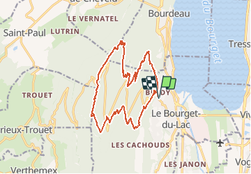
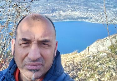
Randonnée Course à pied de 18,8 km à découvrir à Auvergne-Rhône-Alpes, Savoie, Le Bourget-du-Lac. Cette randonnée est proposée par pzellner.

Profil altimétrique

Localisation

Pays :
France
Région :
Auvergne-Rhône-Alpes
Département/Province :
Savoie
Commune :
Le Bourget-du-Lac
Localité :
Unknown
Départ:(Dec)
Départ:(UTM)
722147 ; 5059593 (31T) N.

Randonnées à proximité

Randonnée V.T.T. Aix-les-Bains - Randolac 2008 - Epine Chat Chambotte - Photo
V.T.T.
tracegps

V.T.T.

Très difficile
(1)
Aix-les-Bains, Auvergne-Rhône-Alpes, Savoie, France
64 km | 94 km-effort
7h 0min
Oui
Randonnée Marche Le Bourget-du-Lac - La Dent du Chat 1390m, le Molard Noir 1452m - Photo
Marche
tracegps

Marche

Difficile
(4)
Le Bourget-du-Lac, Auvergne-Rhône-Alpes, Savoie, France
6,6 km | 13,7 km-effort
3h 30min
Oui
Randonnée V.T.T. Le Bourget-du-Lac - Chartreuse - Col du Crucifix - Photo
V.T.T.
tracegps

V.T.T.

Difficile
(2)
Le Bourget-du-Lac, Auvergne-Rhône-Alpes, Savoie, France
27 km | 40 km-effort
4h 0min
Oui
Randonnée Marche Saint-Jean-de-Chevelu - La dent du chat - Photo
Marche
tippex01

Marche

Difficile
(1)
Saint-Jean-de-Chevelu, Auvergne-Rhône-Alpes, Savoie, France
3,1 km | 9,8 km-effort
1h 30min
Non
Randonnée Via ferrata La Chapelle-du-Mont-du-Chat - 2011-04-03 via ferrata Col du chat - Photo
Via ferrata
phschaefer

Via ferrata

Facile
(1)
La Chapelle-du-Mont-du-Chat, Auvergne-Rhône-Alpes, Savoie, France
3,6 km | 6,8 km-effort
Inconnu
Non
Randonnée Marche Le Bourget-du-Lac - Dent du Chat,  Mollard Noir,  Refuge du Relais du Chat au départ du Sentier Botanique  - Photo
Marche
Zasa

Marche

Moyen
Le Bourget-du-Lac, Auvergne-Rhône-Alpes, Savoie, France
12,8 km | 25 km-effort
4h 0min
Oui
Randonnée Marche La Chapelle-du-Mont-du-Chat - 270523 Tour et Dent du Chat - Photo
Marche
mzonzon05

Marche

Facile
La Chapelle-du-Mont-du-Chat, Auvergne-Rhône-Alpes, Savoie, France
10 km | 21 km-effort
4h 15min
Oui
Randonnée Marche Le Bourget-du-Lac - mixte Pierre Nioule/croix du signal  - Photo
Marche
Zasa

Marche

Facile
Le Bourget-du-Lac, Auvergne-Rhône-Alpes, Savoie, France
11 km | 21 km-effort
3h 0min
Oui
Randonnée Marche Le Bourget-du-Lac - Le Molard du mont du Chat - Photo
Marche
crocau

Marche

Très facile
(1)
Le Bourget-du-Lac, Auvergne-Rhône-Alpes, Savoie, France
3,1 km | 4,5 km-effort
1h 32min
Oui


Fermer
Mes abonnements